


Map Surveyor app for iPhone and iPad
Developer: 健 李
First release : 22 Mar 2015
App size: 8.44 Mb
The most concise operation, the most professional map measurement tools.
Route distance, area, perimeter? There is no problem!
Anchor point mark, fingers crossed, a variety of operating method!
It can export the KML files, and email it!
Ads, IAP, background refresh? Function limitation? No!!!!!
In the age of the watching-face, nothing is more important than GOOD-LOOKING UI?
Beautiful, concise, frosted glass effect, symmetrical design. YES!! We all have!!!!!
Accuracy? Are you asked about accuracy?
For a developer with 20 years experience of surveying and mapping, this is an insult.
It is not only an App, it is a comfort to your eyes.
It is not only an App, it is a pleasure of operation.
The right thing, is, download it!
We will update more function later.
Function introduction?
Are you really need?
Press on the buttons!
Tap, drag, swipe, pan, long tap on the map!
You will understand!
Enjoy the pleasure of discovery!
=======================
Special statement: the above App’s description is not wrote by me!
The following content is:
This App is a graceful, concise, powerful map measuring tool, it allows you to quickly and accurately measure the distance of route, the area and perimeter of the closed shape, the point‘s coverage.
The tool can meet the needs of your precise measurement. You can use it at work or in life, whether you are a surveyor, an architect, an athlete, a courier, a planner, a fan of geography, a sports fan, a farmer, or a gardener,... , no matter how much or how small you need to measure, you can benefit from this App.
“MapSurveyor” can make your iPhone, iPod touch and iPad, become a powerful portable measuring tool.
[Feathers]
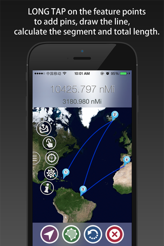
1, Mark feature points with pins, and then drawing line and area.
2, Shaking your iPhone/iPad to add pins.
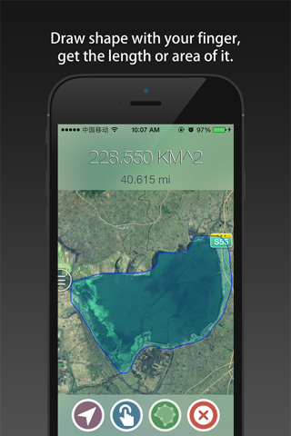
3, Draw shape with your finger, displaying in line way, then form a closed polygon.
4, Calculate the length of the route, and summary it.
5, Calculation the area of a irregular polygon.
6, Calculate the perimeter of a irregular polygon.
7, Support undo and clear operations.
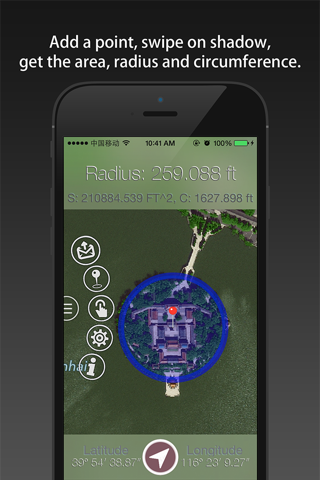
8, According to the center point, give the area, radius, circumference of a circular area.
9, Support for getting the users location.
10, Can connect two points with geodesic or common line.
11, Support length unit: meter, kilometer, foot, mile and li.
12, Support area unit: square meter, square kilometers, square foot, square mile and mu.
13, Can save the shapes to album, and share it with email (PNG file).
14, Support use email to share data, with TXT and KML file.
15, After entering the background, automatically turn off the GPS function.
16, support above iOS 8.0 version, iPhone, iPod touch and iPad.
17, Clean: NO Ads, NO IAP, NO background refresh, NO function limitation.
............
More function is in designing, we will update this App continuously.
[Operation Method]
Long Tap on the map to add pins.
Menu is hidden in the left edge of view, you can tap it to switch views.
Note:
Need Internet connection to download or update the map data.
[Usage Examples]
1, use it to measure an irregular polygon, such as a farm, a block, a district, a city, etc.
2, use it to plan an outdoor travel, calculate the length of the route, provide accurate information for your travel.
3, use it to measure the distance between you and the nearest subway station.
4, use it to view your life circle including 200 km.
5, compare the two cities which is near/far more.
6, distance measurements: use the App to get user’s current location in realtime, shaking to add pin, can actually measure the length of the stroke.
7, field measurements: travel around a region with your iPhone, use the user current location increase anchor point, finally form the closed area, and then the area of the region can be obtained.
If you have any questions and suggestions, please email to [email protected].